InMapz Auditor™ · Field Inspection Maps

Find every asset in the field, down to the blue dot.

InMapz Auditor is the map-first outdoor field inspection app: GPS-accurate equipment locations, before/after photo verification, and crew work routes for outdoor assets. Walk up to the right valve, pole, or panel — without a senior tech holding your hand.

Free plan · forever iOS · Android · Web GPS & satellite maps

Your audit team runs on spreadsheets and memory.

The equipment is out there. The location is in someone's head. By the time the new crew finds it, half the day is gone — and nobody can prove the work was done.

  • 01 Senior tech retires; site knowledge walks out with them Turnover risk
  • 02 New crew spends half a day finding the equipment ~4 hr/visit
  • 03 Equipment goes missing between audits — written off CAPEX leak
  • 04 Client disputes whether the work was actually done No proof
  • 05 Inventory spreadsheets out of sync across phones, email, paper Data errors

One field map. Blue dot, GPS pin, photo proof.

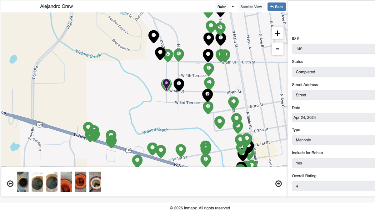
Open the app onsite. See your position as a blue dot. Walk straight to the asset. Snap before and after photos. The work is logged, dated, geo-stamped, and visible to the office in real time.

~Mins
To find any
asset in field
25%
CAPEX recovery
on lost assets
Free
Forever plan,
full features
Map my assets

Three field-ready layers on top of the map.

Indoor maps locate rooms. InMapz Auditor locates equipment in the world — outdoors, where floor plans end — with GPS-accurate pins, photo proof, and crew work routes that follow the asset, not the desk.

Pillar 01

GPS-accurate asset maps

Every piece of equipment pinned with GPS coordinates. Walk up to it onsite — your blue dot guides you. No more "it's behind the third pump, you'll know it when you see it."

  • Satellite and street map views
  • Blue-dot current position in the field
  • GPS coordinates for reports and audits
  • Unlimited equipment per project
Pillar 02

Photo-verified work

Photos are the truth. Before-and-after photos are stamped with date, time, and GPS — and tied to the asset on the map. Proof for clients. Proof for auditors. Proof for yourself.

  • Before/after photos per asset
  • Geo-stamped and time-stamped
  • Unlimited photo hosting included
  • Client-ready proof-of-work reports
Pillar 03

Work routes for crews

Assemble a route, assign it to a crew, track status by color on the map. Office knows what's done, what's in progress, what's blocked — without a single phone call.

  • Build routes from any asset selection
  • Color-coded status by equipment
  • Mobile crews, web office dashboard
  • Reduce data-entry errors in the field

If it has a location, InMapz Auditor remembers it.

From streetlights to irrigation valves to switchgear, the same map handles every category of outdoor asset your team inspects. One project, unlimited equipment types.

Outdoor lighting & electrical

Streetlights, parking lot poles, pathway and landscape lighting, transformers, switchgear, outdoor panels, EV chargers, meters, conduits. Audit fixtures, log lamp types and wattage, flag outages with a photo.

Outdoor & grounds

Pipes, sprinklers, irrigation, trees, gardens, landscaping. GPS pins where rooms and floor plans don't exist. The outdoor map most facilities tools can't handle.

Factories, farms, utilities

Machinery, parts inventory, materials-handling equipment, utilities, outdoor storage. One project handles assets across multiple yards, lots, and field sites.

Today's work route 6 OF 12
Sprinkler Z-04 — Spring check INSP-0414 · Zone A · 9:12am · ✓
Done
Backflow Preventer #2 INSP-0415 · Zone A · 9:48am · ✓
Done
Pump Station B INSP-0418 · Zone B · M. Chen
Now
Light Pole 14 — Lamp swap INSP-0421 · Zone C · M. Chen
Next
Tree audit — Row 7 INSP-0424 · Zone D · M. Chen
Queue

Mobile-first. Office-connected.

The crew uses the phone. The office uses the web. Same project, same data, same map — synced in real time. No emailing spreadsheets back and forth.

01

iOS app

iPhone and iPad. Map, pins, GPS, photos, route status. Field-ready in your pocket. Free plan includes full mobile access.

02

Android app

Phones and tablets, ruggedized handhelds. Same features as iOS. Same project sync. No platform compromise.

03

Web portal

Office, home, anywhere with a browser. Plan routes, review photos, run reports, manage users. Map and table views of the same data.

04

Real-time sync

Crew snaps a photo in the field; the office sees it instantly. Status colors update live. Cloud hosting for maps, equipment data, and photos — included.

Three steps. Same day.

01
Create a project
Spin up a site, campus, or portfolio. Free plan, no credit card. The map is ready to receive pins.
02
Mark equipment locations
Walk the site. Drop a pin, snap a photo, type the asset name. GPS coordinates captured automatically.
03
Assign work routes
Build a route, assign a crew, monitor by color. Realize the time savings on the very next inspection cycle.

Free to start. $199/user when you scale.

InMapz Auditor is the only InMapz product with a forever-free tier — one user, one project, unlimited equipment, full mobile and web access, full cloud hosting included. Pro unlocks unlimited projects and team support.

Free
$0/forever
  • 1 user · 1 project
  • Unlimited equipment
  • iOS · Android · Web
  • All hosting included
Talk to sales

Things field teams ask before signing up.

How is InMapz Auditor different from InMapz X Facilities Maps?
InMapz Auditor is built for outdoor field inspection work — equipment audits across outdoor sites with GPS pins, blue-dot positioning, before/after photos, and crew work routes. InMapz X is the facilities operations platform for indoor buildings with work orders, preventative maintenance, and CMMS-style workflows. Many customers use both: Auditor for the outdoor field crews; X for the building operations team.
How accurate are the GPS coordinates?
InMapz Auditor uses your device's GPS to mark and locate equipment, typically 3–5 meters of accuracy outdoors on a modern phone. For higher precision, the app supports external GPS receivers and RTK devices over Bluetooth.
What does the free plan actually include?
One user license, one project, unlimited equipment of any type, full iOS and Android apps, full web portal, and full cloud hosting for maps, equipment data, and photos. Free forever. No credit card required. The free plan is the same software the Pro plan runs on — just scoped to a single user and project.
Can I use Auditor without internet in the field?
Yes. The mobile apps cache your project map and equipment data for offline use. Pins, photos, and status updates queue locally and sync the moment the phone reconnects — essential for remote sites, rural inspections, and dead-zone areas common on large outdoor properties.
Does Auditor work alongside InMapz X or our existing CMMS?
Yes. Field audits in Auditor can roll up into InMapz X work orders, and the platform exposes a REST API for two-way sync with most CMMS, IWMS, and ITSM tools. Most teams start with Auditor's free plan, then layer in InMapz X for building operations as they scale.
How fast can a new crew member get productive?
Most crews are field-productive within a single shift. The interface is the map — drop a pin, snap a photo, tap done. No clipboards, no spreadsheets, no senior-tech ride-along required. The map replaces the institutional knowledge that used to live in one person's head.
Show us one site. We'll show you the map.

Pick a site you know inside out. We'll demo InMapz Auditor on it — and you'll see exactly how your field crew would use it on the next inspection cycle.

20 minutes · Free plan available same day · iOS · Android · Web